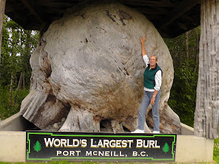
Not really, we just took a drive to the end of the paved highway at the North end of Vancouver Island for Canadian Adventure #4. A windy, partially cloudy day of site-seeing and geocaching. Don located 10 along the way, but the best were the two at Coal Harbour due to their location on the shore of Holberg Inlet on Quatsino Sound. This area played a strategic roll during WWII due to its proximity to the Pacific. Many of the small villages and towns have creative signs, but the gold medal winner for today was Port Hardy, who had 3 signs all equally spectacular. Tomorrow we’ll be heading back to Nanaimo but this time on Hwy 19 instead of the scenic route we took to get here.
 |
We traveled from Telegraph Hill to Coal Harbour
Can you find it? |
 |
| Low tide again - Port Hardy |
 |
| Loved this sign at the highway |
 |
| Later there was this beauty |
 |
| and finally this one as we entered the harbor area... |
 |
This is what you don't want to see as you're heading
up a dirt road to geocache...bad for the paint job!!! |
 |
When you get a reading like this, perhaps you should
take the hint. We didn't... |
 |
| and proceeded to Coal Harbour |
 |
| where these two guarded the entrance |
 |
| to the wharf. |
 |
After walking thru a 3' wide "cut" in a massive
wild blackberry patch we discovered this great tree |
 |
Don found his cache the berry bushes.
|
 |
Then we walked down the beach 1/4 mile
as the tide was coming in... |
 |
| The name of this geocache "Tree on a Stump" |
 |
Look closely, a red cedar grew on top of
an old cedar stump...it's roots are running
down the edge of the stump and into the ground. |
 |
| On the way back... I know, just one more photo |


No comments:
Post a Comment